Air Alerts in Ukraine: Official Maps and Mobile Applications

Air Alerts in Ukraine: Official Maps and Mobile Applications
According to Главком: Air alerts in Ukraine have become an important part of life for the population since the onset of the full-scale invasion by Russia on February 24, 2022. In response to new threats related to the war, interactive online maps of air alerts have been created to provide timely information to citizens about dangers.
The mobile application 'Air Alert' is available for Android and iOS users. This application is one of the main tools for quick access to information about air alerts and other threats. The official map of air alerts in Ukraine is available through several links, including:
- https://map.ukrainealarm.com/
- https://alerts.in.ua/
These resources help citizens navigate the situation.
Additional Maps and Symbols
Furthermore, there is an emergency situation map available at https://alarmmap.online/, as well as Yemap, which is available on the website https://vadimklimenko.com/map/. Another important map is the siren map in Ukraine, accessible at the link https://kopiyka.org/s/. These maps provide additional information for the population, allowing for better responses to threats.
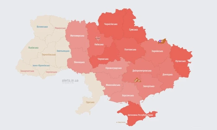
The official maps of air alerts in Ukraine use certain symbols:
- red color - air alert;
- orange - threat of artillery shelling;
- green - threat of street battles.
Other maps also have their symbols: on the simple alert map, the orange color means an announced air alert, while blue indicates no alert in the area. On the siren map, red denotes an announced alert, and gray indicates no alert.
In times of uncertainty and threats, air alerts and accompanying resources become crucial for ensuring the safety of the population in Ukraine. This emphasizes the need for prompt responses to challenges arising in wartime conditions.
The situation in Ukraine remains complicated, so informational resources that ensure timely information about air alerts are vital for preserving the lives and health of citizens. The use of mobile applications and online maps allows people to respond quickly to threats, which is especially important in the context of the ongoing conflict and constant security risks.
Read also