

‘Air Alarm’ App Launches Enemy Drone and Missile Movement Map to Enhance Public Safety


Introducing a New Tracking Feature in the 'Air Alarm' App
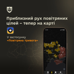
According to ХВИЛЯ: The 'Air Alarm' app has been updated with a new feature: a map displaying the approximate movement of hostile drones and missiles. This tool aims to provide users with rapid access to verified information during attacks, reducing the need to rely on unconfirmed sources. Prime Minister Serhii Koretskyi announced this development on Facebook.
Collaboration Behind the Innovation and Its Significance
This mapping system was developed through a joint effort involving the Ministry of Digital Transformation, the Ministry of Defense, the Ukrainian Air Force, and local IT companies. It is important to note that the map does not display the exact real-time locations of threats.
"Every minute counts during aerial attacks when it comes to public safety. That’s why having quick access to military-verified information is crucial, so people don’t waste precious time searching unreliable sources,"
Serhii Koretskyi
The Prime Minister also urged citizens to immediately seek shelter and remain there until the all-clear is given whenever an alarm is sounded.
This latest addition to the 'Air Alarm' app marks a significant advancement in protecting civilians amid ongoing military threats. Providing timely, authenticated updates helps reduce panic and enhances public readiness during emergencies. The collaboration among government agencies and IT experts highlights Ukraine’s commitment to leveraging technology in safeguarding its population.

Read also