Online battle map of Ukraine as of July 3: situation at the front

According to glavcom.ua: The 'Glavkom' website has published a collection of online maps that will help better understand the situation at the front in Ukraine and track the gradual liberation of territories from the occupiers.
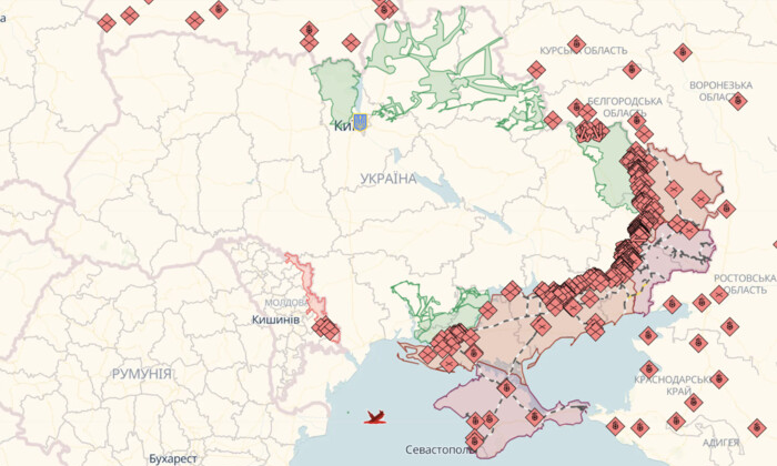
Deep State Map
Legend on the Deep State map:
- blue: territory liberated in the last two weeks
- green: liberated territory
- gray: territory requiring clarification
- red: territory occupied by Russians
- dark red: territory of Crimea and ORDLO
- light red: occupied territories of other states
The map also shows railways, units, headquarters, airfields, and the directions of enemy attacks.
Liveuamap
Legend on the Liveuamap:
- red: territory occupied by Russians
- blue: territory liberated from Russians
Additionally, this map marks important military facilities and events both within Ukraine and abroad.
ISW (Institute for the Study of War) battle map
ISW constantly updates its battle map by analyzing the situation at the front.
Dear citizens!
It is important to follow official sources of information and avoid spreading fakes during wartime when truthful information becomes particularly significant. Be aware of disinformation and support our army!
Glory to Ukraine!
This article presents three online battle maps of Ukraine that help monitor the situation at the front and track the gradual liberation of territories from the occupiers. It also emphasizes the importance of obtaining reliable information from official sources and supporting the Armed Forces of Ukraine in the fight against the enemy.
Read also