Unusual Ocean Warming Detected in the Pacific by NASA Ahead of El Niño Event

Tracking the Early Signs of El Niño Formation
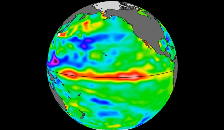
According to НВ — Техно: NASA and its European partners are monitoring a significant buildup of warm water in the Pacific Ocean, which could signal the development of a new El Niño event. Data from the Sentinel-6 Michael Freilich satellite has revealed a zone of abnormally warm water stretching hundreds of kilometers off the coast of South America. Kelvin waves-generated when winds shift direction over the western equatorial Pacific-are now moving eastward, a pattern that often precedes the onset of El Niño.
Sea levels near the Peruvian coast are currently more than 15 centimeters above the long-term average. This warming process began later than it did during the powerful El Niño events of 1997 and 2015. Josh Willis, a sea level researcher at NASA’s Jet Propulsion Laboratory, commented:
“The current process started a bit later than during the strong El Niño events of 1997 and 2015, but it is gradually gaining strength. It’s still too early to assess its final scale.” - Josh Willis
Launched in 2020 as part of the Copernicus program, the Sentinel-6 Michael Freilich satellite measures ocean surface height every 10 days. Sea-level satellites like Sentinel-6 make it possible to track large Kelvin waves, monitor changes in Earth’s oceans, and improve forecasts of extreme weather events. Nadya Vinogradova Shiffer, head of NASA’s science program, emphasized:
“Sea-level satellites allow us to track large Kelvin waves as they move across the Pacific, capture changes in Earth’s oceans, and improve predictions of extreme weather events, helping communities prepare for potential coastal risks.” - Nadya Vinogradova Shiffer
How El Niño Affects Global Climate
El Niño typically peaks between November and January, and while each event has its own unique characteristics, it almost always brings higher global temperatures and shifts in rainfall patterns across different parts of the world. Severin Fournier, a researcher at NASA’s Jet Propulsion Laboratory, noted: “Every El Niño has its own features, but these events are almost always accompanied by rising global temperatures and noticeable changes in precipitation across various regions.”
Sea level observations have been ongoing since 1992, and the launch of the Sentinel-6B satellite is scheduled for November 2025. It is expected to take over the mission’s primary functions by the end of 2026. The strong El Niño of 2015–2016 was linked to drought in Africa and flooding in California, underscoring the importance of monitoring such phenomena to prepare for potential impacts. Moderate El Niño episodes occurred in 2018 and 2023, demonstrating the persistent nature of this climatic pattern.
Tracking the formation of El Niño is crucial not only for the scientific community but also for the general public, as this phenomenon can have serious consequences for climate across various regions worldwide. Changes in ocean temperature and atmospheric conditions can affect agriculture, water resources, and the overall health of ecosystems. Therefore, monitoring and forecasting such events will help countries prepare for potential risks and adapt their resource management strategies.
As scientists continue to monitor the warming waters, the likelihood of El Niño's impact on global weather patterns is becoming increasingly concerning. With a 90% probability of the phenomenon approaching, understanding its potential effects is crucial for communities worldwide.
Read also